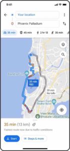
An update to Google Maps will see toll road prices added to the web mapping platform for the first time, Google has announced.
The company said it is adding toll prices on Google Maps to make it easier for users to choose between taking toll roads or regular roads.
Users will see the estimated toll price to their their destination before they start navigating. The toll prices will be provided by local tolling authorities.

To calculate the estimated toll price of a trip, Google will look at the cost of using a toll pass or other payment methods, what the day of the week it is and how much the toll is expected to cost at the specific time its crossed.
According to Google, users will still have the option to choose to avoid seeing routes with toll roads altogether through the app’s settings.
Users will start to see toll road prices on Android and iOS this month for nearly 2,000 toll roads in the USA, India, Japan and Indonesia, with more countries planned to be added soon.
Google also announced that it is adding new details to the app’s navigation experience to make it less stressful to drive on unfamiliar roads by adding traffic lights and stop signs.
Users will also see enhanced details such as building outlines and areas of interest. In some cities, users will see more detail, such as the shape and width of a road, including medians and islands.
The new navigation map will start rolling out to select countries in the coming weeks on Android, iOS, Android Auto and CarPlay.
You can learn more about the key trends and challenges affecting senior decision-makers who have responsibility for tolling, intelligent transportation systems and road pricing at the 19th annual Road User Charging Conference in Brussels, Belgium on 04-05 May 2022. Visit www.roaduserchargingconference.co.uk for more information.


